What is an IGS, as seen on old Kai Tak Airport charts? And how does this differ from the more commonly known ILS approaches?
Posted on January 25 2021


Well first let’s cover what an ILS (Instrument Landing System) approach is. It is another radio navaid that guides aircraft into landing, referred to as a type of ‘precision approach’ as they give guidance vertically as well as laterally, as opposed to a ‘non-precision approach’ only providing lateral guidance. Hence, is used for most landings, but especially during instrument conditions where a pilot may only see the runway in the final moments before landing.
How do they work?
It works by sending signals up to the aircraft via 2 ground based radio transmitters. One is the localiser (LOC), giving lateral guidance, signaling if the aircraft is flying left or right of the runway centerline. The other is the glide slope (GS), giving vertical guidance, signaling if the aircraft is high or low.
Marker beacons, such as Outer (OM), Middle (MM - as the Checkerboard approach had) and Inner (IM) markers, which, extending from the runway centerline, were used as either distance indicators or indicators for decision height points. At these decision heights, as the term suggests, a decision must be made if the approach may be continued. If the specified visual reference is positively identified, continue the landing. Otherwise a go-around must be performed.
The approach can be done manually, however autopilot can also perform the approach and is usually preferred during low visibility conditions.
So to answer the original question, an IGS (Instrument Guidance System) is a modified ILS which does not fulfil all the required ICAO ILS standards. It uses the same principles of the ILS however the localiser or glideslope is not able to align the aircraft directly to the runway. In the case of Kai Tak Airport, the reason for this was the terrain as there were mountains that prevented a straight in approach. The breakaway point from following the Kai Tak IGS to visual being at the MM and the visual reference was the Checkerboard hill. A few of these approaches still exist, such as Lugano Airport (LSZA) in Switzerland which lines up with the runway but has a 6.65 degree steep glide path(compared with a 3 degree normal ILS); and Mostar Airport (LQMO) in Bosnia and Herzegovina, that carry a similar spirit to the Kai Tak IGS approach.
====================
舊啟德機場航圖上的IGS係代表啲咩?同ILS又有咩分別?
要了解IGS系統,首先要先介紹一下ILS(Instrument Landing System)。ILS 是一種引導飛機降落的無線電導航系統,因為它們在垂直和水平方向上都提供引導,所以算是一種「精確進場」(Precision Approach)系統;而「非精確進場」(Non-Precision Approach) 例如 VOR NDB 則僅提供水平方向上的指導。因此ILS 的應用十分普及,亦令飛行員可以在能見度低時可以把飛機對準跑道進行降落。
ILS如何運作?
ILS 通過兩個地面無線電發射器向飛機發送信號。一個是Localizer(LOC),可提供橫向引導,發出信號指示飛機是在跑道中心線的左側還是右側。另一個是Glide Slope(GS),可提供垂直引導,指示飛機是高或低。
從跑道中心線延伸出來的位置配有 Marker Beacon ,例如外部 Outter Marker(OM),中間 Middle Marker(MM)和內部 Inner Marker(IM)用作距離指示或 Decision Height/Altitude 決策高度位置的指示。在Decision Height/Altitude 決策高度,飛行員如果可以見到跑道或燈號,便可以繼續降落;而如果天氣差見不到,便要Go Around 復飛。
飛行員可以手動按ILS訊號飛行,而 Auto Pilot 自動駕駛亦可以按ILS訊號飛行。部分機場跑道高規格的系統更可精準引導飛機到地面,配合機上系統作出全自動降落。通常在低能見度條件下會選用自動方式降落。
回答最初的問題,IGS(Instrument Guidance System)是「不完整」的ILS。它使用了與ILS相同的原理,但是不合乎ICAO對 ILS 的引導要求,例如因無法將飛機直接對準跑道,令飛行員必須以目視操作完成最後一部分。就啟德機場13跑道而言,因為有山勢阻礙了進場的上空,所以要用IGS把飛機由低地引導進入降落的位置。13跑道 IGS 的 視覺參考是格仔山 (Checkerboard hill),如果在Middle Marker見到格仔山,才可以繼續降落。瑞士的盧加諾機場(LSZA)和波斯尼亞的莫斯塔爾機場(LQMO)亦使用了IGS系統。 前者LSZA 的IGS 雖然對正跑道線,但下降斜道為 6.65度,遠超一般ILS大約 3度的斜道。
--------------------------------
(Photo: Phill Parker - Civil Aviation Department - retrieved from https://www.cad.gov.hk/english/photogallery_70th.html)
=======================
More Posts
-
![Royal Air Force Ensign]()
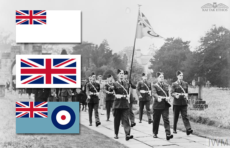
100 years since the...
24 March 2021 marks the centenary of the birth of the Royal Air Force Ensign. There are a few types of flags within the RAF, such as the one and o...
Read More -
![The First Generation of Super Transport Aircraft - the Super Guppy]()
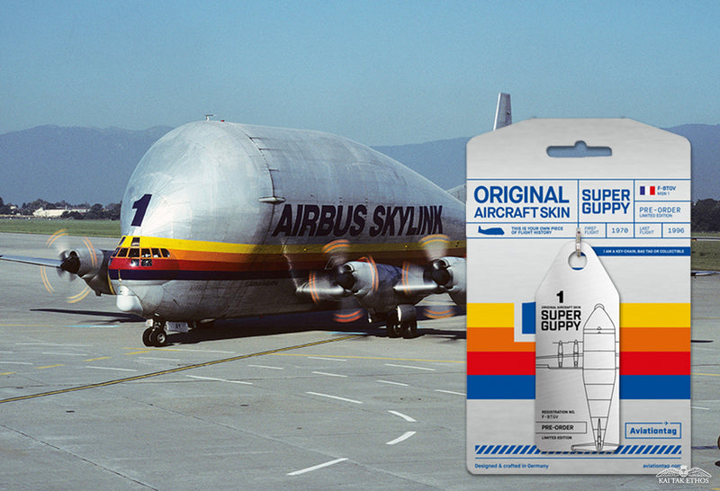
The First Generatio...
The first generation of legendary super transport aircraft in history is the weird-looking "Frankenstein’s Monster" of the aviation world - the Sup...
Read More -
![Happy International Women’s Month!!]()
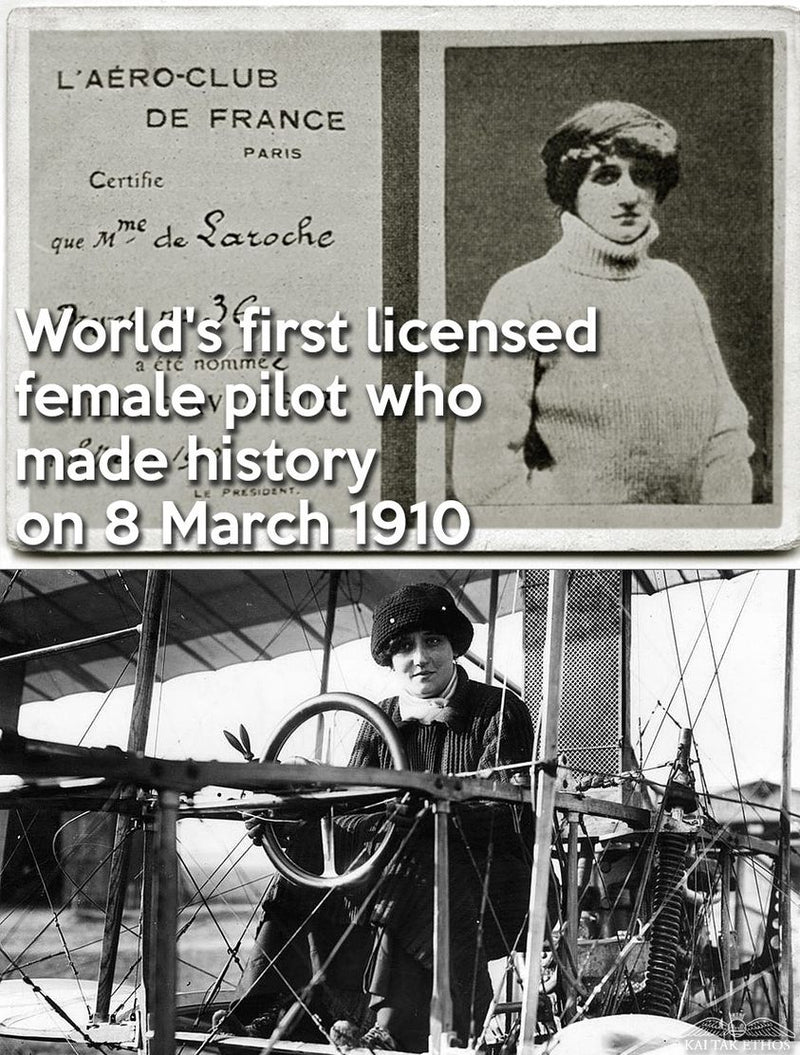
Happy International...
We are lucky to have many women idols in aviation - representing courage, endurance and power of all the women in the world. On this special month...
Read More


Comments
0 Comments
Leave a Comment